Confederation Heights: Realize the Potential

Canada Lands Company and Public Services and Procurement Canada (PSPC) worked together, along with a broad range of stakeholders, to develop a comprehensive Master Plan for Confederation Heights. The Master Plan will establish a vision for the site, which is expected to transition over the next 25 years from an automobile-oriented federal employment hub into a mixed-use, sustainable community.
About the Partners
![]()
Canada Lands Company is a self-financing federal Crown corporation that specializes in real estate development and attraction management. Its mission is to obtain the best economic and community value from former government properties and the management and operations of certain attractions such as the CN Tower and Downsview Park in Toronto, and the Montreal Science Centre and the Old Port of Montreal.

Public Services and Procurement Canada (PSPC) is responsible for managing office space for federal departments and agencies across Canada. Its portfolio currently includes a significant portion of lands and buildings in Confederation Heights.
Objectives of the Master Plan
The current City of Ottawa Confederation Heights Secondary Plan is approximately 25 years old and requires an update to ensure that it meets the needs of a growing city. The goal is to turn Confederation Heights into a complete community that provides amenities, connections, housing, and employment that will appeal to a wide and diverse population.
The area’s history and context, including proximity to the Rideau River, National Capital Commission parkland, and planned public transit infrastructure will shape the master plan and address aspects such as land uses, building heights, densities, site design, sustainability, housing, parks and open space, heritage considerations, as well as pedestrian, cycling, transit and vehicular connections and wayfinding.
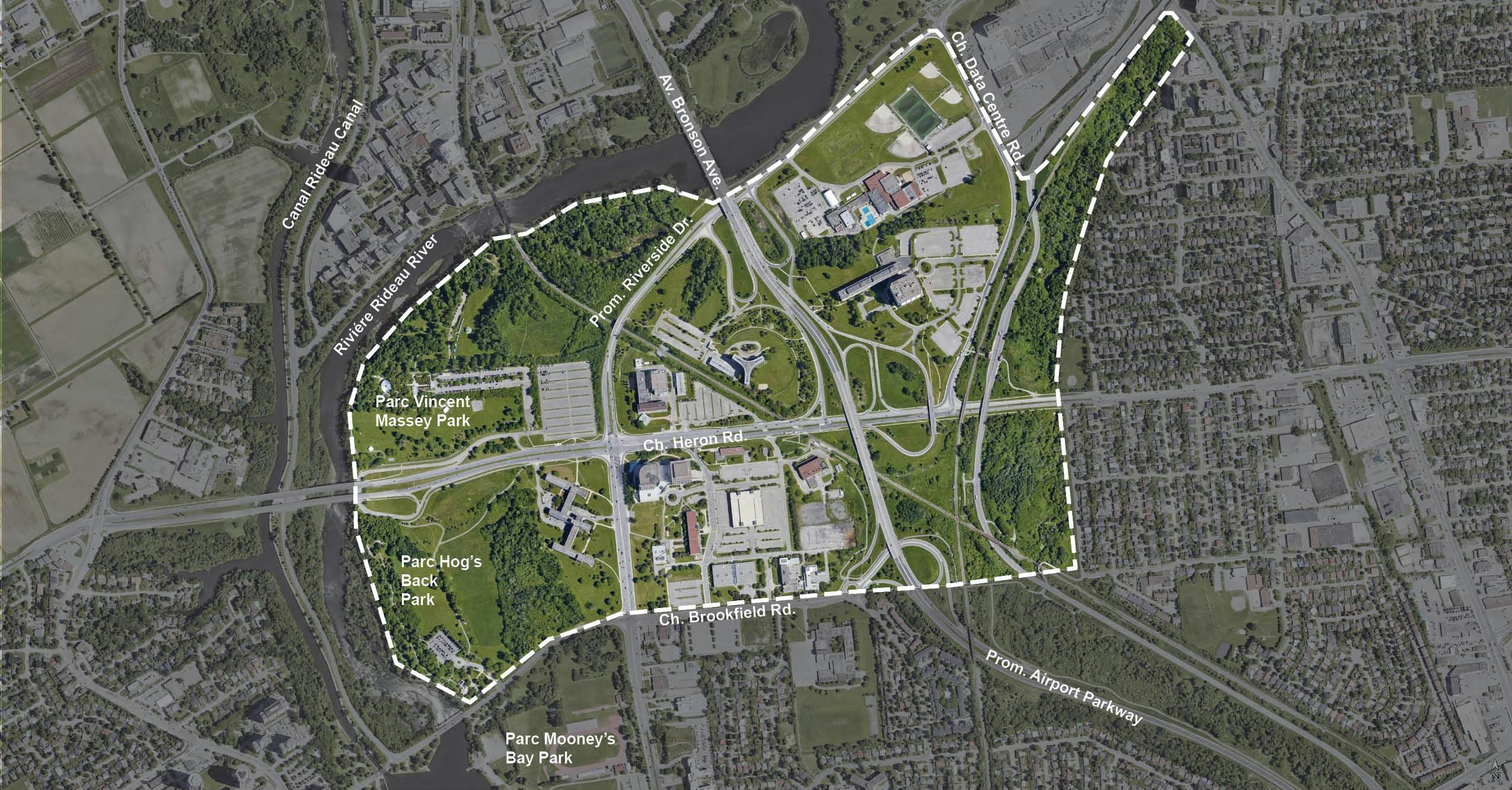
Overview of the Site

Confederation Heights is currently a federal employment area located approximately five kilometres south of Ottawa’s downtown core, totalling approximately 188 hectares/465 acres. The site is bound by the Rideau River to the north and west, Data Centre Road and Sawmill Creek to the east, and Brookfield Road to the south. Property owners on and adjacent to the study area include the Government of Canada, the National Capital Commission, Health Canada, Canada Post, the City of Ottawa, and CN Rail.

Learn
Learn more about the history and evolution of the site here 
Next Steps
Canada Lands Company has worked to keep the community informed about the Confederation Heights redevelopment through public engagement activities that began in November 2021. Throughout this period, community members and stakeholders have been able to share input during both the master planning process. The Final Draft Master Plan, presented at a public Open House in January 2026, reflects this work and will help guide the long-term development of the area. Since 2025, the City of Ottawa have joined these public engagement activities, allowing for community members and stakeholders to provide feedback to the secondary plan process.
As the project moves into the municipal approval phase, the City of Ottawa will now be leading the next steps for the Confederation Heights Secondary Plan.
To continue staying in the know on next steps, visit the City of Ottawa’s Confederation Heights Secondary Plan page.
Indigenous Land Acknowledgement
We recognize that the City of Ottawa is located on the traditional and unceded territory of the Algonquin Anishinabe People who have lived on this land for millennia. We extend our respect to all First Nations, Inuit and Métis peoples for their valuable past and present contributions to this land. We also recognize and respect the cultural diversity that First Nations, Inuit and Métis people bring to the City of Ottawa.
Stories
Tell us about your experiences, recollections, or stories of Confederation Heights. Your input will undoubtedly inspire our designers and planners as we develop a new master plan for the site.
If you prefer to share your story directly with the team, please send us an email at confederationheights@clc-sic.ca.
-
Share Meadow Commute on Facebook Share Meadow Commute on X (formerly Twitter) Share Meadow Commute on Linkedin Email Meadow Commute link
Meadow Commute

I really enjoyed commuting via a shortcut through a butterfly meadow (at least for a few weeks every year until the city mows it). I would often see butterflies and urban wildlife. After biking from the south up Sawmill Creek Pathway, I can get directly onto Bronson and continue north (map below, red arrow), avoiding a big hill. The only downside is immediately noticing the comparison with the unnecessarily mown areas just north of it (blue circle) (these areas are not used for road safety/visibility). I get some weight-lifting in too -- my bike over the guardrail!
Who's Listening

Custom

STAY INFORMED

