FAQs
- Establish detailed policies for land use, building heights, and public realm
- Adapt the Official Plan's policies to fit local contexts
- Guide development within villages
- Support public transit and affordable housing
- Consider the historic significance of existing buildings, streets, and greenspaces
General
Why is PSPC reducing its footprint at Confederation Heights?
Since the launch of this collaboration project Canada Lands Company and Public Services and Procurement Canada (PSPC) have been working towards, and engaging stakeholders, Indigenous communities and the public on a new vision for the site that will realize the site’s potential. Part of that work included PSPC determining its future at Confederations Heights as part of the government’s portfolio reduction strategy.
After careful analysis, PSPC has determined its future footprint at Confederation Heights and while the federal government will continue to have a presence at Confederation Heights it will be less than it had previously.
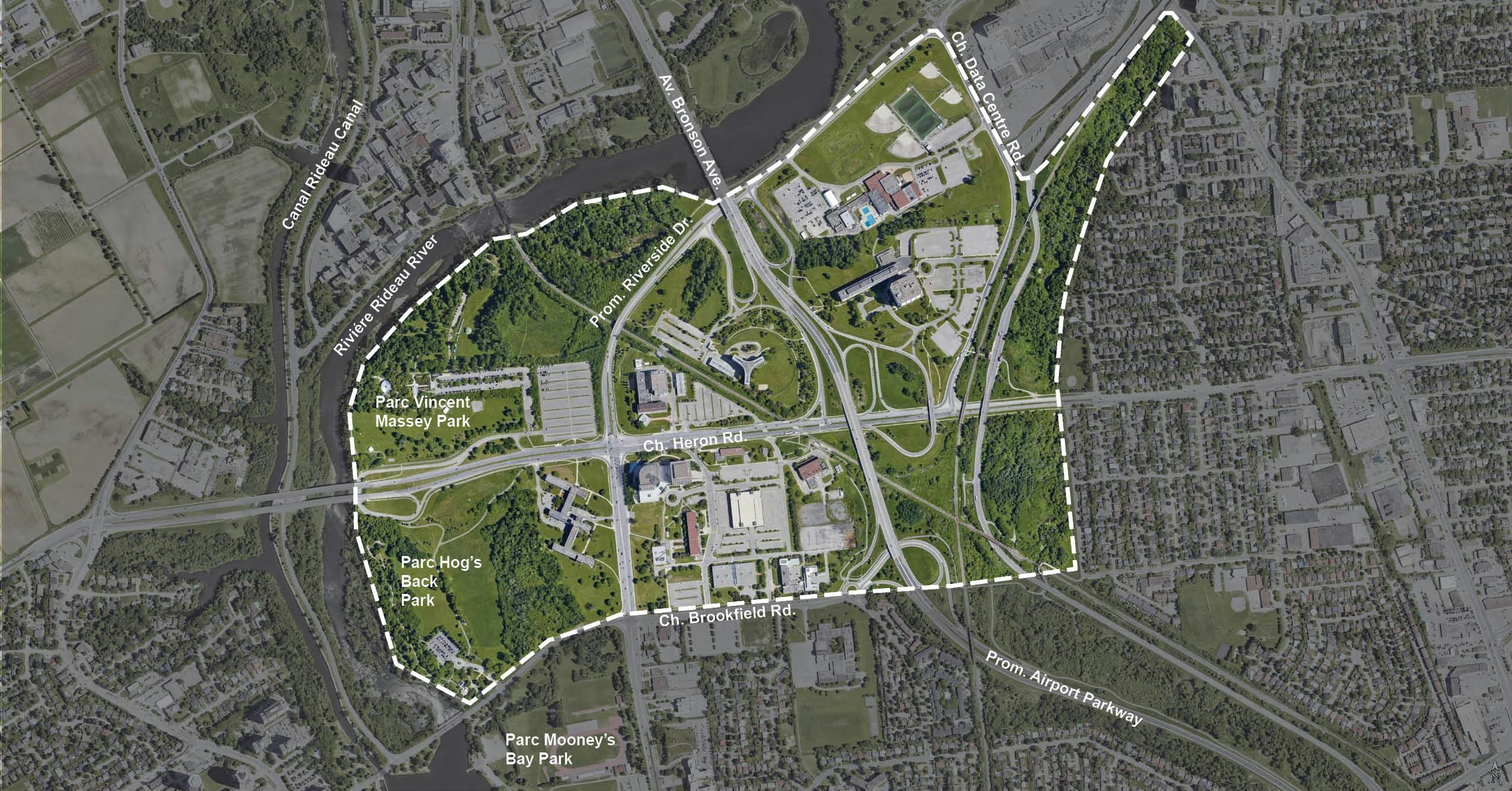
This map will provide an overview of the study area for Confederation Heights.
Why has Canada Lands Company been tasked with the redevelopment of Confederation Heights?
Canada Lands Company is the Government’s real estate development arm and has 30 years of experience of success redeveloping former federal lands into vibrant communities.
What is the NCC’s role now? Has it changed?
As an important adjacent landowner and federal approval body, the NCC plays an important role in the redevelopment of Confederation Heights, and Canada Lands is currently working closely with them regarding their role in the federal disposal process as well as ensuring the site’s heritage and design considerations as a gateway to the Capital and connectivity around and through NCC parks are incorporated.
Now that PSPC will have a smaller footprint and more land is now available for housing will Canada Lands Company restart the master planning process?
The feedback received from the public, stakeholders, community groups, Indigenous communities and the advisory committee has been clear, Confederation Heights should be a mixed-use community with housing, green spaces, safe connections, be transit-oriented, and have sustainability at its core while being a gateway to Canada’s capital. Those principles remain and having a reduced federal footprint provides Canada Lands Company an opportunity to enable even more of these desires. The current master planning process continues to move forward assessing additional lands and preparing a draft Master Plan in conjunction the City’s Secondary Plan process.
Why are we talking about ‘realizing the potential’ of Confederation Heights?
Confederation Heights is governed by several federal and municipal policies that have evolved over the years to encourage a greater number of people and jobs to be located on existing urban, serviced lands, particularly in proximity to existing or planned public transit. This site has the potential to deliver a complete community. There is already amazing access to transit with one operational Bus Rapid Transit (BRT) transitway route that runs along the eastern edge of Confederation Heights parallel to Sawmill Creek and the O-Train line 2 that bisects Confederation Heights in a north-south direction as Light Rail Transit. In addition, the future development of a new BRT route along Heron Road, which cuts east-west across Confederation Heights is being planned by the City.
In October 2021, the City of Ottawa Council approved a new Official Plan for Ottawa, which will guide growth in the City for the next 25 years. The new Official Plan identifies Confederation Heights as a “Hub” due to its proximity to transit, a designation which is planned to provide a mix of uses at transit-supportive densities.
Pedestrian and cycling connectivity within Confederation Heights and to surrounding areas is currently characterized by barriers such as elevated and wide, busy roads and transit corridors, as well as below-grade crossings in select locations (which are not fully accessible). There is an opportunity to improve these connections to benefit all users (present and future) of the site, including those arriving by transit, walking or cycling. Pedestrian and cyclist-friendly connections would help integrate Confederation Heights into the broader community.
The redevelopment of Confederation Heights also offers the unique opportunity to celebrate the heritage and long history of the site including recognizing and honouring Indigenous heritage, the Gréber Plan, the built heritage and the significant accomplishments of federal departments that have occupied the site over its history. Canada Lands Company continues to advance work on an appropriate heritage plan including opportunities for adaptive re-use and commemoration.
The government announced a public land bank in August 2024, including three properties at Confederation Heights. What does this mean for this redevelopment?
The three Confederation Heights properties included as part of the Canada Public Land Bank were already slated to be part of the Confederation Heights Master Plan. This announcement does not change this and only means that their development may be expedited as builders may express interest sooner in these parcels. The development of these parcels will be undertaken with the same commitment to transparency and public engagement that Canada Lands Company has already initiated with the community and stakeholders.
Master Plan
What is a Master Plan and what does it contain?
The Confederation Heights Master Plan will establish a long-term vision for the site and inform a new municipally approved Secondary Plan. The Master Plan will consider such aspects as the possible land uses on site, minimum and maximum building heights, minimum and maximum densities, housing, the location and size of parks and open spaces, pedestrian, cycling, transit and vehicular connections, and guidance for heritage preservation, commemoration, and wayfinding.
It will also include urban design guiding principles that will provide direction and enough flexibility to allow the plan to evolve over time.
Who has Canada Lands Company contracted to assist in the development of the Master Plan?
Fotenn Planning + Design from Ottawa, Ontario has been contracted to act as the lead consultant for this project. Fotenn is supported by a group of professionals of various technical disciplines.
Secondary Plan
What is a Secondary Plan?
From the City of Ottawa website:
A Secondary Plan in Ottawa is a policy document that guides growth and change in specific areas of the city. Secondary Plans are part of the City's Official Plan, which provides a vision for the City's future growth.
What do secondary plans do?
What municipal approvals are being sought?
Canada Lands Company will be seeking Master Plan approval through the City of Ottawa Secondary Plan process. Canada Lands and/or future builders will then seek site plan municipal approvals for any of the development blocks. The public will be able to provide further input through these processes.
Why is the City of Ottawa launching a Secondary Plan process?
The City of Ottawa’s Official Plan provides a vision for the future growth of the City and a policy framework to guide the City's physical development. Ottawa’s Official Plan includes Secondary Plans that provide more detailed guidance and adapt Official Plan policies to a local context. In collaboration with Canada Lands and PSPC, the City of Ottawa has launched a new Secondary Plan to help guide the future redevelopment.
The City is seeking to align our shared goals resulting in a new Secondary Plan for Confederation Heights within a planning horizon of 20 years. This Plan will include direction on land uses, densities, building heights and other design requirements, new connectivity requirements and public realm improvements to ensure the area develops into an entirely new neighbourhood and destination for Ottawans. Establishing a planning and design framework at the municipal level will enable the timely and orderly implementation of the vision, including clarity for the community, property owners and developers, and City staff when considering future redevelopment proposals for the area.
The City of Ottawa website has more information regarding the Secondary Plan process.
Construction
When will construction start at Confederation Heights?
Once the final Master Plan and Secondary Plan are complete and approved by the City of Ottawa, a phasing and implementation plan will be developed, which will be followed by additional municipal approvals for such things as plan of subdivision applications. Construction activities for new development are expected to begin after municipal approvals are obtained. Canada Lands will explore with the City, PSPC and other stakeholders opportunities to streamline processes and find efficiencies where possible to enable housing faster.
Engagement
What other stakeholders are involved in the master planning process?
Canada Lands and PSPC are working with Canada Post, Health Canada, the NCC, City of Ottawa, public utilities, federal tenant groups, and the RA Centre, among others.
What is different now compared to the last time Canada Lands and PSPC were engaging the public?
Here is a brief update:
Canada Lands Company has been asked to address the country’s housing crisis by enabling housing faster. Canada Lands is using the tools at its disposal in order to do so, including finding collaborative ways to expedite processes. The City of Ottawa as an approval body has been very involved and cooperative in this goal. Together Canada Lands and the City are working on two processes in parallel: the finalization of Master Plan and Secondary Plan approval.
Has there been engagement with Indigenous communities during the master planning process?
Yes. PSPC and Canada Lands are jointly engaging with Indigenous communities and organizations through an independent parallel process. PSPC and Canada Lands continue to solidify these important relationships.
Transportation/Connections
Are there other initiatives being undertaken in the study area?
The City of Ottawa has recently completed the light rail transit station and adding double tracking, as part of the Stage 2 expansion of the system. As well, the City is planning a bus rapid transit route along Heron Road and Baseline Road.
Will there be changes to the existing road network? What will be done about the high traffic speeds and unsafe walking/cycling conditions in Confederation Heights?
The Master Plan vision and guiding principles highlight the importance of making Confederation Heights a place that is accessible, safe, and attractive to travel through and to by car, public transit, bike and on foot. The Master Plan team is continuing its work with the City of Ottawa to determine how the road network will appropriately support non-vehicular modes of transportation in addition to vehicles. Feedback provided by the public is being considered as part of the process.
Will the number of parking spaces/lots be reduced?
A major objective of the Master Plan is to make it safer and easier to walk, take public transit or bike in Confederation Heights. Much of the developable land is where parking lots currently sit. Under the City of Ottawa parking by-law, there is currently no parking minimum for the Confederation Heights area as it is located near a major transit station.
Canada Lands will develop a parking strategy and transportation modal splits to determine what the future parking supply will be, along with infrastructure to encourage and support more sustainable transportation choices. We are engaging with adjacent landowners and tenants to understand their transportation needs and priorities. This input will be incorporated into the parking strategy and future stages of the Master Plan.
Sustainability
What is the future of district energy in Confederation Heights?
PSPC’s Energy Services Acquisition Program (ESAP) will continue to supply heating and cooling services to all buildings currently connected to its district energy system in Confederation Heights. New buildings may be added to the district energy system as the Master Plan advances.
There is currently work in place to modernize the district energy system, which will result in a 92% overall reduction in GHG emissions in the National Capital Region (NCR), which Confederation Heights is part of, as compared to a 2005 baseline. Further reduction of the remaining NCR district energy system network’s greenhouse gas emissions is part of the ESAP future program of work, pending funding availability, where PSPC is targeting further greening solutions to be net-zero by 2050.
Housing
Will there be affordable housing on the site?
The Master Plan’s eventual land uses will identify and inform opportunities for affordable housing.
The Master Plan municipal approval process will require a minimum 20% contribution across the site as outlined in the Official Plan and Canada Lands’ own commitment. The implementation, phasing and municipal approval stage will define more details regarding the total number of units, housing types and allocations within the phases of development for affordable housing to be realized.